
MAPP-certified partners can perform methane emissions studies for landfills, biogas, and renewable natural gas (RNG), along with surface emissions monitoring (SEM), faster, safer, and more accurately while driving revenue with industry-leading technology designed specifically for landfill gas detection.
More methane leak detection data and actionable insights than ever before.

The SnifferDRONE™ Surface Emissions approach follows a preprogrammed serpentine path and operates at a constant altitude using an umbilical for measuring methane concentrations from landfill air samples. A nozzle at its end captures gas from vegetation and surface irregularities, directly measuring methane at the emission point. Each measurement’s precise location is captured in SRI’s GIS software to identify the leak source for remediation.
The information collected from SnifferDRONE is uploaded to the cloud to generate the industry's most comprehensive location, concentration, and quantification reporting. By manually verifying leak locations, wellheads, and penetrations, MAPP technicians can enhance the reports by tagging precise leak locations with photographs detailing any areas of concern.

Seeing is believing with fast, standardized reports.
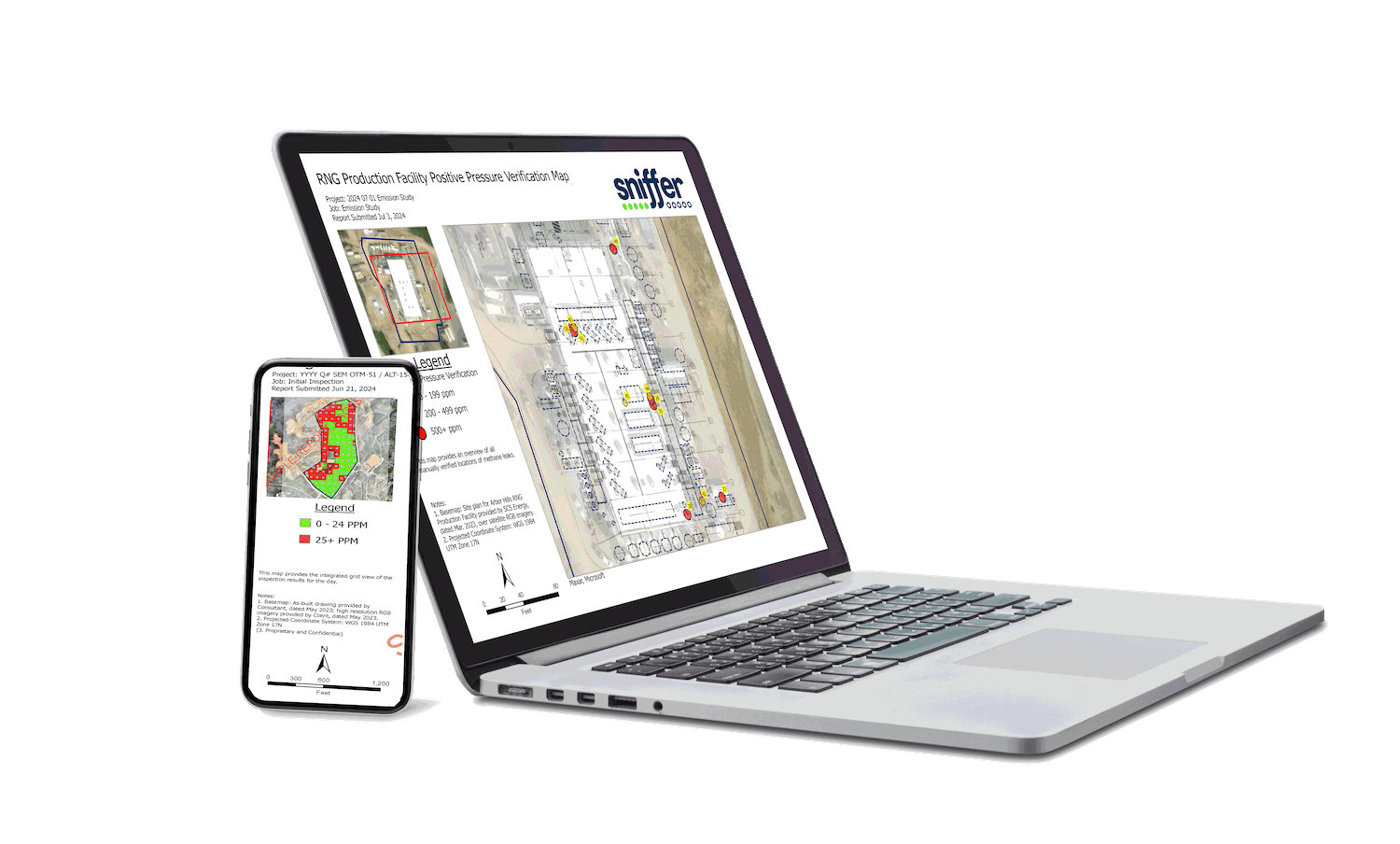
SnifferVIEW™ delivers full-color visualizations consisting of interpolated maps, instantaneous leak source maps, integrated grid maps, exceedance and areas of concern maps, penetration inspection maps, detailed listings of exceedances, captioned photographs, and more. Standardized reports can be produced quickly, some within one business day of study completion, while real-time insights are available on mobile devices with Sniffer Field Ops™.

About MAPP
How it Works.
MAPP companies enter into an annual licensing agreement for access to the SnifferDRONE, Sniffer Field Ops, and SnifferVIEW™. SRI provides training, marketing, field support, data analytics, and reporting.
Are SnifferDRONES for sale?
No. Only certified technicians can operate the SnifferDRONE payload.
Are MAPP partnerships available globally?
Absolutely. Methane emissions are a global issue. SRI is expanding its network of technicians and MAPP partners in the US and abroad to meet demand. Join the movement!
How to obtain a gas study without becoming a partner.
Sniffer Robotics employs nationwide technicians for methane detection at landfills, RNG plants, and biogas facilities.
Contact SRI for a cost estimate.
MAPP Companies get access to Sniffer's out-of-the-box Drone Surface Emissions Monitoring (DSEM) package and enjoy numerous competitive advantages:

Hardware
Proprietary SnifferDRONE™
(Gen II) Payload

-
Payload compatible with commercially available quadcopters
-
The most precise method for surface emissions monitoring
-
Sensitive to parts-per-billion sampling at 3Hz
-
Laser-guided sensor maintains constant height through surface undulations
-
Approved by the US Environmental Protection Agency (EPA)
-
Included in Canadian ECCC draft regulations
-
Faster and more efficient than walking surveys with more accurate localization
-
Increased safety for field personnel
-
Reliable and repeatable serpentine paths for comparative results analysis
-
4K Aerial imagery for cover integrity and penetrations
Software
Sniffer Field Ops™
-
Industry-leading comprehensive methane analysis and reporting software
-
Desktop and mobile access to results within 24-hours day of inspection
-
Integration with ArcGIS
-
Compatible with high-resolution imagery and engineering drawings
-
Analytics to optimize gas capture and maximize throughput
-
Color-coded visuals for clear identification of methane exceedances
-
Analytics for gas recovery
-
Multiple map views:
-
Exceedance and areas of concern
-
Interpolated methane concentration heat maps measured at-surface (1 ppm – 100% CH4) Discrete leak
-
locations with >90% accuracy
-
Fugitive gas emissions rate (SCFM) by cell or cover system
-

Methane Analysis Partner Program (MAPP)

Understanding the Benefits of drone surface emissions monitoring compared to walking surface emissions monitoring for methane detection and quantification.
While the traditional method of walking a landfill with a handheld CH4 detector (see US EPA Method 21) can be effective in finding methane gas leaks and emittances, it is also labor intensive, hazardous, and prone to inaccurate and inconsistent data collection due to human error. Conversely, the use of autonomous technology offered with drone surface emissions monitoring (see US EPA OTM-51) increases the accuracy, safety, and consistency of data collection for methane leak detection and quantification.